Some Caribbean islands greet you with a sprawling terminal and a wall of taxi drivers. Saba greets you with a cliff.
The “Unspoiled Queen” — a single volcanic peak rising straight out of the sea about 28 miles southwest of St. Maarten — is one of the hardest islands to reach in the region, and one of the most rewarding. There are no direct international flights, no cruise piers and no resort strip. Reaching it comes down to two choices: a 12-minute flight onto the shortest commercial runway on the planet, or a 90-minute crossing by fast ferry. Both begin in St. Maarten, which is the single gateway to everything Saba.
That means the first leg of any Saba trip is really a flight to St. Maarten’s Princess Juliana International Airport, the busy Dutch hub that connects to most major U.S. and European cities. Time your arrival for the morning or early afternoon. The last hop to Saba leaves before dark, because Juancho E. Yrausquin Airport has no runway lights, and the ferries run on daytime schedules.
The flight is the headline act. Winair is the only carrier running scheduled service to Saba, flying the De Havilland Twin Otter, a sturdy 19-seat turboprop built for exactly this kind of short-field, steep-approach work. There are roughly four daily flights from St. Maarten, the crossing takes about 12 minutes, and one-way fares typically run $142 to $147, with day-trip pricing available for those who want to land, hike and fly out the same afternoon. Sit on the right side leaving St. Maarten for the best angle on the island as it materializes out of the open Atlantic.
Then comes the landing. Juancho E. Yrausquin Airport has a single runway of roughly 1,300 feet — the shortest in commercial aviation — wedged onto a shelf of rock with cliffs at one end and the sea at the other. Pilots train specifically to fly it, and the approach is part white-knuckle, part theater. It is, without exaggeration, one of the great arrivals anywhere in the world.
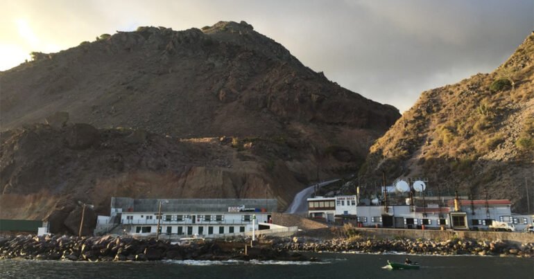
If small planes are not your style, or weather has the airport socked in, the sea route is the alternative. Saba is now served by two ferry operators, the Edge and the Makana, both crossing in about 90 minutes and both landing at Fort Bay, the island’s working harbor. The Edge, a wave-piercing catamaran, sails from Simpson Bay on Tuesdays and Fridays, leaving around 9 a.m. and departing Saba for the return at about 3:30 p.m. — a clean window for a day trip. The Makana, a 150-passenger fast catamaran, runs a more frequent schedule and also links Saba to Sint Eustatius and St. Kitts, which makes it the better bet for anyone island-hopping across the Dutch Caribbean.
A few things to plan around. Both the planes and the harbor are at the mercy of the weather, and delays are common enough that you should build a buffer day rather than connecting to a same-day international flight out of St. Maarten. Pack light, since the Twin Otter has firm baggage limits. And bring a passport, as Saba is a separate immigration entry even when you are arriving from elsewhere in the Dutch Caribbean.
What waits at the other end justifies the effort. From Fort Bay or the airport, taxis climb a single switchbacking road to The Bottom, the tidy capital, and on to Windwardside, the village that anchors the island’s hiking and dining. Above it all sits Mt. Scenery, at nearly 2,900 feet the highest point in the entire Kingdom of the Netherlands, with a cloud-forest trail to the summit. Offshore, the Saba Marine Park protects some of the most celebrated wall and pinnacle diving in the Caribbean.
There are no beaches to speak of and no crowds to fight. On Saba, getting there has always been half the story.
Caribbean Journal Staff
2026-06-07 19:55:00