
The slow-moving but increasingly powerful Hurricane Melissa continued to churn toward Jamaica on Sunday, its maximum sustained winds reaching 145 miles per hour — with even higher gusts recorded by NOAA’s Hurricane Hunters.
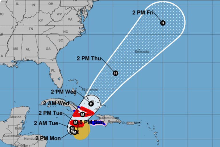
By Sunday evening, the storm’s eye was located about 115 miles southwest of Kingston and roughly 295 miles southwest of Guantanamo, Cuba. Melissa’s pace remained sluggish — just five miles per hour — a worrying sign for forecasters tracking what’s now a Category 4 hurricane on the Saffir-Simpson scale.
A Hurricane Watch remained in effect for Jamaica and parts of eastern Cuba, including the provinces of Granma, Santiago de Cuba, Guantanamo, and Holguin. The system is expected to continue moving slowly westward before turning north and northeast by Monday and Tuesday, putting Jamaica directly in its path.
A Tropical Storm Warning was also issued for the southwestern peninsula of Haiti, from the Dominican Republic border to Port-au-Prince, and for Cuba’s Las Tunas province.
The National Hurricane Center emphasized that “a Hurricane Warning means that hurricane conditions are expected somewhere within the warning area,” generally issued about 36 hours before the first tropical-storm-force winds arrive — conditions that make final preparations dangerous. Authorities across Jamaica have urged residents to complete all safety measures by Sunday night.
Forecasters now expect Melissa’s core to move near or over Jamaica on Tuesday, then cross southeastern Cuba Tuesday night before sweeping over the southeastern Bahamas on Wednesday.
Melissa’s hurricane-force winds extend outward up to 30 miles from the eye, with tropical-storm-force winds reaching as far as 205 miles. The storm’s central pressure has dropped to 933 millibars, signaling continued intensification over warm Caribbean waters.
Impacts and Rainfall Threat
Tropical-storm conditions are already being felt in parts of Jamaica, with hurricane conditions expected to begin by Monday. In eastern Cuba, tropical-storm-force winds are anticipated by Tuesday afternoon, followed by hurricane conditions by Tuesday evening. Haiti’s southwestern coast is experiencing tropical-storm conditions, and hurricane-force winds remain possible in the watch area.
Melissa’s most dangerous impact, however, could come from rainfall. Forecast models indicate 15 to 30 inches of rain across portions of Jamaica, with localized totals up to 40 inches, triggering catastrophic flash floods and landslides. Southern Hispaniola could see 8 to 16 inches, while eastern Cuba faces totals of 10 to 15 inches, with localized peaks near 20 inches.
Over the southeastern Bahamas, rainfall totals between 4 and 8 inches are expected through midweek, bringing potential flash flooding in low-lying areas.
Authorities across the Caribbean are urging residents to stay informed through their national meteorological services, as additional watches and warnings may be issued later tonight or Monday.
Hurricane Melissa is forecast to remain a major Category 4 storm as it nears Jamaica — a powerful and dangerous system with the potential to bring life-threatening winds, rain, and storm surge across multiple islands in the days ahead.
Caribbean Journal Staff
2025-10-27 00:37:00